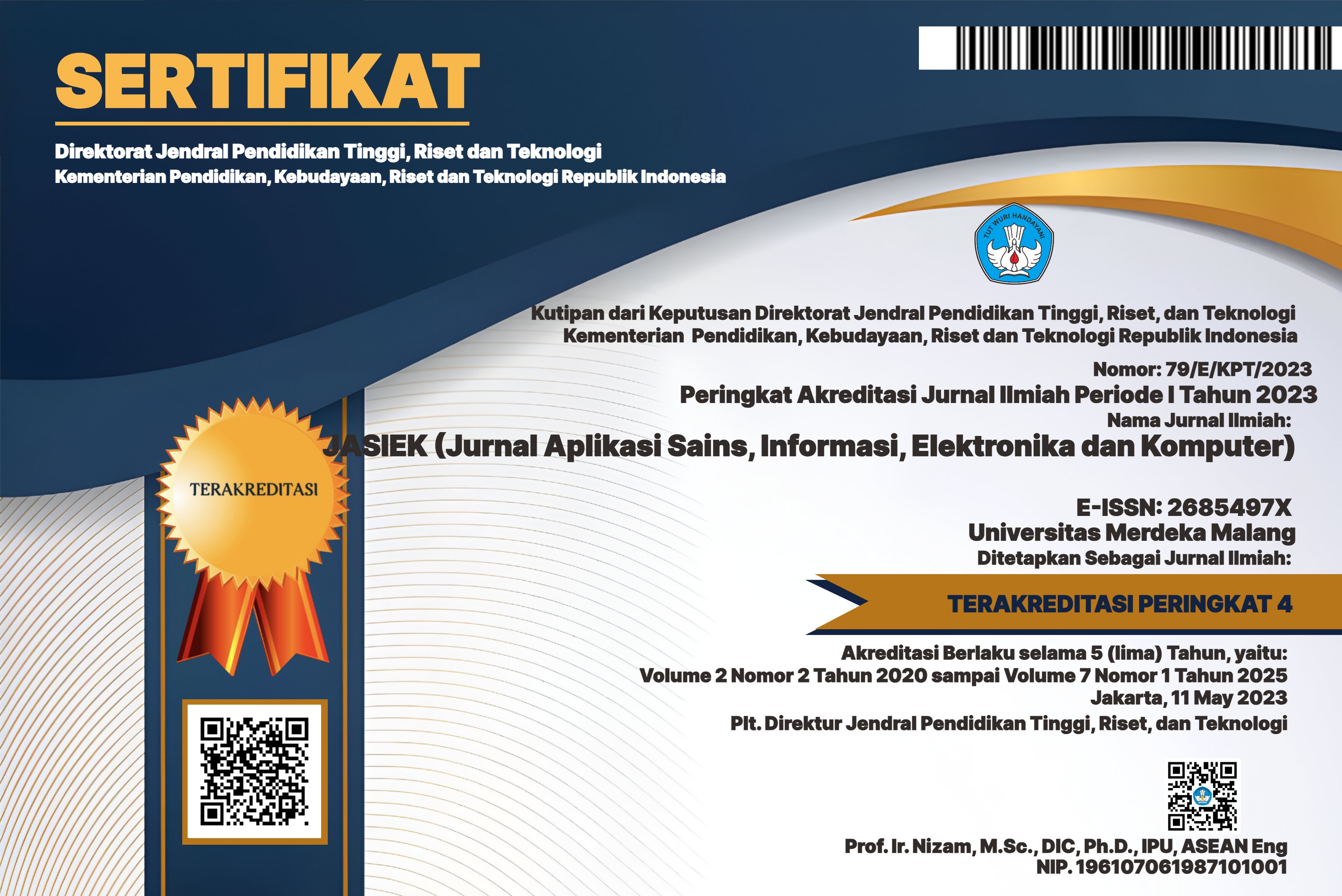
B-Shinance: Aplikasi R-Shiny Interaktif untuk Percepatan Visualisasi Daerah Potensi Banjir Berdasarkan Uji Dominasi
DOI:
https://doi.org/10.26905/jasiek.v5i2.11546Keywords:
Bencana banjir, R, Shiny, Skyline Query, VisualisasiAbstract
Bencana banjir merupakan salah satu bencana yang sering terjadi di Indonesia. Beberapa penyebab terjadinya banjir yaitu perubahan tutupan lahan, penggunaan lahan dan curah hujan yang tinggi. Banjir dapat diantisipasi atau dampak banjir dapat diminimalisir dengan cara mengidentifikasi daerah potensi banjir berdasarkan kondisi dari suatu daerah. Proses identifikasi daerah potensi banjir dapat dilakukan dengan menerapkan skyline query. Dimana skyline query dapat mengidentifikasi daerah yang paling unggul atau dominan berdasarkan karakteristik daerah yang berpotensi banjir. Penyajian hasil skyline query akan lebih mudah dipahami ketika dikembangkan atau diterapkan ke dalam suatu sistem atau aplikasi. Sehingga dalam penelitian ini mengembangkan suatu aplikasi interaktif untuk percepatan visualisasi daerah potensi banjir dengan menerapkan skyline query. Aplikasi dikembangkan dengan menggunakan R dan library shiny untuk mempercepat penerapan alogirtma dan pengembangan aplikasi. Aplikasi yang dikembangkan dalam penelitian ini yaitu B-Shinance.Downloads
References
M. Majeed et al., “Prediction of flash flood susceptibility using integrating analytic hierarchy process (AHP) and frequency ratio (FR) algorithms,†Front Environ Sci, vol. 10, Jan. 2023, doi: 10.3389/fenvs.2022.1037547.
J. Wu, J. Li, Z. Zhu, and P.-C. Hsu, “Factors determining the subseasonal prediction skill of summer extreme rainfall over southern China,†Clim Dyn, vol. 60, no. 1–2, pp. 443–460, Jan. 2023, doi: 10.1007/s00382-022-06326-w.
X. Guan, C. Xia, H. Xu, Q. Liang, C. Ma, and S. Xu, “Flood risk analysis integrating of Bayesian-based time-varying model and expected annual damage considering non-stationarity and uncertainty in the coastal city,†J Hydrol (Amst), vol. 617, p. 129038, Feb. 2023, doi: 10.1016/j.jhydrol.2022.129038.
J.-H. Wang, G.-F. Lin, Y.-R. Huang, I.-H. Huang, and C.-L. Chen, “Application of hybrid machine learning model for flood hazard zoning assessments,†Stochastic Environmental Research and Risk Assessment, vol. 37, no. 1, pp. 395–412, Jan. 2023, doi: 10.1007/s00477-022-02301-3.
G. Folino, M. Guarascio, and F. Chiaravalloti, “Learning ensembles of deep neural networks for extreme rainfall event detection,†Neural Comput Appl, Jan. 2023, doi: 10.1007/s00521-023-08238-0.
V. Purwayoga, “Modified skyline query to measure priority region for personal protective equipment recipient of COVID-19 health workers,†Jurnal Teknologi dan Sistem Komputer, vol. 9, no. 3, pp. 167–173, Jul. 2021, doi: 10.14710/jtsiskom.2021.14003.
V. Purwayoga and B. Susanto, “Rekomendasi Daerah Penyalur Tenaga Kesehatan Covid-19 Dengan Menggunakan Skyline Query,†Fountain of Informatics Journal, vol. 7, no. 1, p. 22, Oct. 2021, doi: 10.21111/fij.v7i1.5720.
K. Alami and S. Maabout, “A framework for multidimensional skyline queries over streaming data,†Data Knowl Eng, vol. 127, p. 101792, May 2020, doi: 10.1016/j.datak.2020.101792.
Y. Li, “Towards fast prototyping of cloud-based environmental decision support systems for environmental scientists using R Shiny and Docker,†Environmental Modelling & Software, vol. 132, p. 104797, Oct. 2020, doi: 10.1016/j.envsoft.2020.104797.
R. Bakri, B. Sartono, H. A. Zainuddin, and L. A. Sabil, “SWANSTAT: a user-friendly web application for data analysis using shinydashboard package in R,†TELKOMNIKA (Telecommunication Computing Electronics and Control), vol. 18, no. 4, p. 1866, Aug. 2020, doi: 10.12928/telkomnika.v18i4.14182.
E. Jahanshiri and A. R. M. Shariff, “Developing web-based data analysis tools for precision farming using R and Shiny,†IOP Conf Ser Earth Environ Sci, vol. 20, p. 012014, Jun. 2014, doi: 10.1088/1755-1315/20/1/012014.
G. Abriantini, I. S. Sitanggang, and R. Trisminingsih, “Hotspot sequential pattern visualization in peatland of Sumatera and Kalimantan using shiny framework,†IOP Conf Ser Earth Environ Sci, vol. 54, p. 012057, Jan. 2017, doi: 10.1088/1755-1315/54/1/012057.
J. Calderwood et al., “Hotspot mapping in the Celtic Sea: An interactive tool using multinational data to optimise fishing practices,†Mar Policy, vol. 116, p. 103511, Jun. 2020, doi: 10.1016/j.marpol.2019.103511.
G. Boussarie, D. Kopp, G. Lavialle, M. Mouchet, and M. Morfin, “Marine spatial planning to solve increasing conflicts at sea: A framework for prioritizing offshore windfarms and marine protected areas,†J Environ Manage, vol. 339, p. 117857, Aug. 2023, doi: 10.1016/j.jenvman.2023.117857.
E. L. Meyer, C. Kumaus, M. Majka, and F. Koenig, “An interactive R-Shiny app for quickly visualizing a tidy, long dataset with multiple dimensions with an application in clinical trial simulations for platform trials,†SoftwareX, vol. 22, p. 101347, May 2023, doi: 10.1016/j.softx.2023.101347.
G. Skinner et al., “Dynameta: A dynamic platform for ecological meta-analyses in R Shiny,†SoftwareX, vol. 23, p. 101439, Jul. 2023, doi: 10.1016/j.softx.2023.101439.
V. Purwayoga, M. Al Husaini, and H. H. Lukmana, “Visualisasi Skyline Query untuk Distribusi Tenaga Kesehatan COVID-19,†Jurnal Teknik Informatika dan Sistem Informasi, vol. 9, no. 1, Apr. 2023, doi: 10.28932/jutisi.v9i1.5624.
L. Fawcett, “Using Interactive Shiny Applications to Facilitate Research-Informed Learning and Teaching,†Journal of Statistics Education, vol. 26, no. 1, pp. 2–16, Jan. 2018, doi: 10.1080/10691898.2018.1436999.
Downloads
Published
How to Cite
Issue
Section
License
Authors who publish with this journal agree to the following terms:
The journal allow the authors to hold the copyright without restrictions and allow the authors to retain publishing rights without restrictions.
Authors retain copyright and grant the journal right of first publication with the work simultaneously licensed under a Creative Commons Attribution-ShareAlike 4.0 International License that allows others to share the work with an acknowledgement of the work's authorship and initial publication in this journal.
Authors are able to enter into separate, additional contractual arrangements for the non-exclusive distribution of the journal's published version of the work (e.g., post it to an institutional repository or publish it in a book), with an acknowledgement of its initial publication in this journal.
Authors are permitted and encouraged to post their work online (e.g., in institutional repositories or on their website) prior to and during the submission process, as it can lead to productive exchanges, as well as earlier and greater citation of published work (See The Effect of Open Access).

This work is licensed under a Creative Commons Attribution-ShareAlike 4.0 International License.